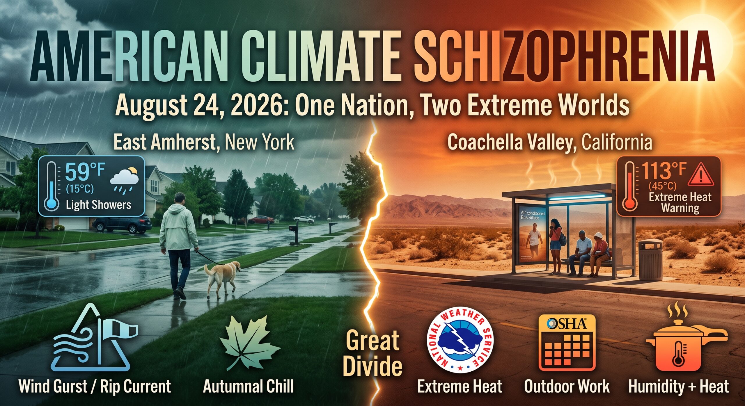
US weather extremes reached a defining peak on August 24, 2026, revealing a striking geographic schizophrenia across the atmospheric map of the United States. If you are waking up in East Amherst, New York, the air is unseasonably cool; a morning low of 59°F and light, intermittent showers suggest the early onset of autumn. Yet, simultaneously, residents of the Coachella Valley are staring down a relentless high of 113°F.
This single 24-hour window encapsulates two radically different versions of the American summer, separated by nearly 50 degrees and a profound “Great Divide” in lived experience. This contrast isn’t just a quirk of the jet stream; it is a testament to how modern climate patterns can hold a jacket-weather morning and a lethal heat emergency in the same breath, forcing us to navigate a map where the “middle ground” is increasingly disappearing.
When “Hot” Breaks the Desert: The Local Standard Paradox
In cities like Phoenix and the communities of the Coachella Valley, high temperatures are the baseline of existence. However, the current Extreme Heat Warning issued by the National Weather Service (NWS)—in effect through Saturday evening, August 29—carries a specific, sobering distinction. It notes that these conditions are dangerous even for populations that have engineered their entire lives around the sun.
Heat warnings are rarely about a raw number on a thermometer; they are calculated based on exceeding the threshold of regional resilience. When a desert community is warned that conditions are extreme “by local standards,” it signals that the atmosphere has surpassed the coping mechanisms of both the power grid and the human body. It is a declaration of a meteorological outlier that threatens the safety of even the most heat-hardened citizens.
“An Extreme Heat Warning means that a period of very hot temperatures, even by local standards, will occur.”
This phrasing marks a shift in how we communicate risk during modern US weather extremes. It indicates that the current event is not a standard “summer day,” but a period where the environment has moved into a state of regional over-capacity.
The Lethal Threshold: Why 911 is the Only Option
The language in modern weather alerts has undergone a notable evolution, shifting from “atmospheric descriptions” to “medical interventions.” The NWS Phoenix and San Diego alerts no longer merely describe the sky; they prescribe a survival response based on a clear physiological escalation.
This progression of heat illness follows a dangerous path:
- Heat Cramps and Exhaustion: The initial failure of the body to regulate salt and moisture levels, resulting in dizziness, heavy sweating, and severe muscle pain.
- Heat Stroke: The terminal point where the body’s internal cooling system ceases to function entirely, causing core temperatures to spike past 104°F, leading to rapid organ failure or death.
The gravity of this shift is best summarized by the NWS’s own blunt command, emphasizing that once the threshold of heat stroke is crossed, the weather is no longer a forecast—it is an immediate casualty event.
“Heat stroke is an emergency! Call 9 1 1.”
The OSHA Protocol: Shifting the Workday
For the labor force, these outliers represent more than a health hazard; they are a fundamental disruption to the modern economy. To mitigate fatalities among outdoor workers in construction, agriculture, and utility maintenance, the Occupational Safety and Health Administration (OSHA) has established strict survival protocols.
Outdoor Worker Survival Checklist:
- Tactical Timing: Reschedule all strenuous labor and heavy physical activity to the early morning or late evening hours.
- Environment Control: Mandate frequent, structured rest breaks specifically in shaded or air-conditioned environments.
- Physiological Protection: Utilize lightweight, loose-fitting, and light-colored clothing to maximize airflow and reflect solar radiation.
- Hydration Discipline: Maintain a rigorous schedule of water intake—at least one cup every 20 minutes—regardless of perceived thirst.
The recommendation to move the workday to the margins of dawn and dusk is a necessary adaptation, but it highlights a difficult reality: as regional temperatures escalate, our traditional 9-to-5 outdoor infrastructure is becoming physically untenable across wide swaths of the continent.
The Monsoonal Wildcard: Humidity Meets the Heatwave
Adding to the complexity of the current map is the “monsoonal wildcard.” While extreme heat remains the primary threat in the southern Plains and Southwest, tropical moisture is simultaneously surging northward. To the west, a tropical system is passing Hawaii’s Big Island, bringing gusty winds, while deep moisture feeds potential flash flooding across the Rockies and Gulf Coast.
The interaction between this moisture and the heatwave is particularly alarming from a physiological standpoint. Humidity complicates heat safety by disrupting “evaporative cooling”—the natural process where the body sheds internal thermal load through the evaporation of sweat. When the air is saturated with monsoonal moisture, sweat remains on the skin rather than evaporating, causing the wet-bulb temperature to spike and preventing the body from cooling its internal core. This monsoonal activity effectively turns a dry heat into a humid pressure cooker, making a 113°F day exponentially more lethal.
The “Cool” New York Anomaly: Rain and Beach Hazards
While the West prepares for a medical emergency, the Buffalo and East Amherst regions of New York are experiencing a meteorological anomaly of the opposite kind. With a morning low of 59°F and a forecasted high of just 67°F, the region is seeing light, intermittent showers with rainfall amounts totaling less than a tenth of an inch.
However, even this cool pocket faces distinct hazards. A “Beach Hazards Statement” is in effect for Northern Erie, reminding residents that mild air temperatures do not guarantee calm waters. Southwest winds of 8 to 15 mph, with gusts reaching as high as 25 mph, are creating dangerous swimming conditions and rip currents along the Lake Erie shoreline.
It is a surreal juxtaposition: while one half of the country is warned not to step outside due to 113°F heat, the other is warned to stay out of the water because of 25-mph gusts and 67°F air.
Our Shifting Baseline
Looking ahead, the 7-day forecast shows Buffalo gradually returning to a seasonal 79°F by midweek. Meanwhile, the Western United States remains trapped under an expansive heat dome, with NWS Extreme Heat Warnings fixed through Saturday night.
As these patterns persist, we are forced to re-evaluate our benchmarks for normal seasonal cycles. We are currently witnessing a shifting baseline where regional infrastructure, civic planning, and emergency systems are repeatedly tested by outliers that refuse to dissipate. Adapting our work schedules, our medical emergency protocols, and our daily behavior is no longer a forward-looking strategy—it is the immediate requirement for surviving a landscape defined by persistent US weather extremes.